WORK TO BE PERFORMED:
Drone Survey for PPDO Project Planning
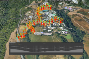
LOCATIONS (See Map):
• West Remote Parking Lot
• Lower Heller Road
• Oakes Road
DETAILS:
• Contractor will be performing remote survey work utilizing unmanned aircraft systems (drones) operated by licensed operators.
• Flight operations will be compliant with UC UAS policy.
• Drone flight path is adjacent to the road, not over the road. The operator will maintain line-of-sight on the drone from the launch area.
• Drone will only cross active roadways a few times, and the drone will pause to ensure the path is clear using on-board visual cameras.
• Operators will maintain an awareness of pedestrians and vehicles and pause as needed to ensure no fly-overs.
TIME:
12:00 PM to 1:00 PM
SCHEDULED DATE:
Thursday, March 26, 2026
IMPACTS:
You may see or hear the drone around the survey areas
MAP OF SURVEY AREA:
Please let us know if you have any questions.
Thank you,
Jenny Coleman – PBSci Facilities
pbsciwodesk@ucsc.edu
831-459-3498